Wyvern Secures Additional Usd $7m In Funding
EDMONTON, Alberta, Canada – November 1, 2022 – Wyvern, a space data company offering affordable and easy-to-access high-resolution hyperspectral imagery, secured an additional USD $7M of funding led by Uncork Capital, with key investors including MaC Venture Capital and Y Combinator.
With the new capital, Wyvern’s first three satellites are fully funded, providing certainty to customers with an interest in purchasing the limited remaining capacity. The latest raise comes in addition to USD $8M of funding secured in two prior investment rounds.
“The funds we’ve raised go towards the launch and operation of Wyvern’s first three satellites which will provide high quality, 5 m resolution hyperspectral imagery to early adopters in early 2023,” says Wyvern CEO Chris Robson. “Industry leaders are seeing the opportunity and taking action, which is exciting and brings new challenges. Even at the fast rate of constellation growth we’re planning, demand will soon begin to outstrip supply and early adopters will be glad to have secured their seats.”
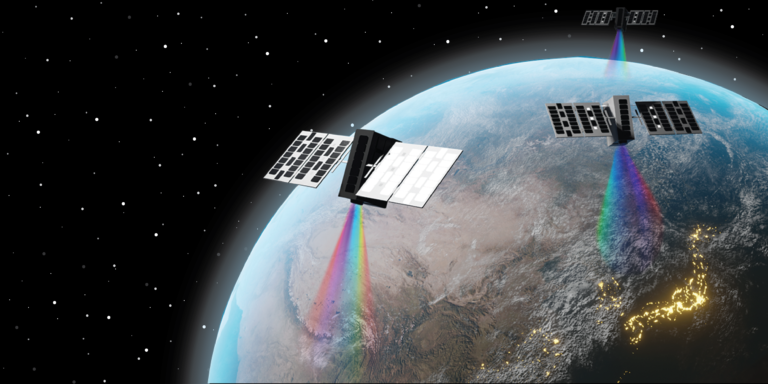
That advantage comes from the unique ability of hyperspectral imaging to reveal chemistry. An advanced spectral imaging technique, hyperspectral compiles images in a combination of visible and non-visible wavelengths to form 3D data blocks. These information-rich blocks reveal unique insights into an area of interest, making it possible to proactively monitor for vegetation stress, methane levels, pipeline leaks and invasive species. The resulting insights will create unprecedented value and efficiencies for industries including agriculture, forestry, environmental and emissions monitoring, energy, and defence.
Hyperspectral imagery has not previously been commercially viable for most industries. Moving forward, the key to Wyvern’s low cost and superior quality will be its unique deployable optics: these next-generation small satellites are being designed by the company’s engineers to unfold in space in a similar fashion to the James Webb Space Telescope.
Another similarity will be in how Wyvern’s deployable satellites will use Shortwave Infrared (SWIR) wavelengths and data channels to show what was previously invisible — enabling breakthroughs and unlocking a wealth of valuable insights.
With Wyvern’s FirstLight program, early adopters secure their access to high-resolution hyperspectral imaging, and the company is creating a customer sandbox to facilitate experimentation and ensure a smooth transition to making the most of insights available through the new technology and platform. Investors have taken note.
“We have been impressed from the get-go by the Wyvern team and their ambition to empower a number of industries with their hyperspectral imagery,” says Jeff Clavier, founder and managing partner at Uncork Capital, a seed-stage venture firm that has backed a large number of multi-billion companies to success since its creation 18 years ago. “Like our other space tech company Loft Orbital, Wyvern is demonstrating the technical innovation and the novel approach that will democratize access to space-based observations.”
The new funding, led by Uncork Capital, was one of several outcomes from Wyvern’s participation in Y Combinator earlier this year.
Chris Robson credits the new funding with helping make Wyvern’s first constellation a certainty and cementing the value for early adopters. “Ultimately, this funding secures more than just satellites. It gets our customers access to a customized ordering platform. It means taskable spectral imaging with a dependable revisit rate. And that, in turn, gives customers the images they need, when they need it.”

Our Data Specifications
Wyvern hyperspectral sensors on our Dragonette satellites will capture data across many narrow spectral bands, allowing for the specific identification of unique chemical and physical properties of the Earth’s surface. This ability makes hyperspectral imagery a valuable tool for a wide range of site monitoring, mapping, and geospatial intelligence (GEOINT) use-case applications.
With a spatial resolution of 5.3 meters, hyperspectral imagery delivered from our Dragonette constellation will provide detailed information about the Earth’s surface. Processed to Level 1B and delivered in GeoTIFF format, we ensure seamless integration of Wyvern’s Dragonette data into your existing systems, workflows, and processes.
Want To Learn More?
Explore the wonders of our first-generation satellites! Delve into our Generation One page for in-depth insights into Dragonette-001, -002, and -003. Uncover the remarkable world of our pioneering satellite technology.
Contact Us
If you’re eager to delve deeper into the realm of hyperspectral data or have any questions about how it can revolutionize your industry, we’re here to assist you. Our team of experts is equipped with extensive knowledge and experience in harnessing the power of hyperspectral technology.